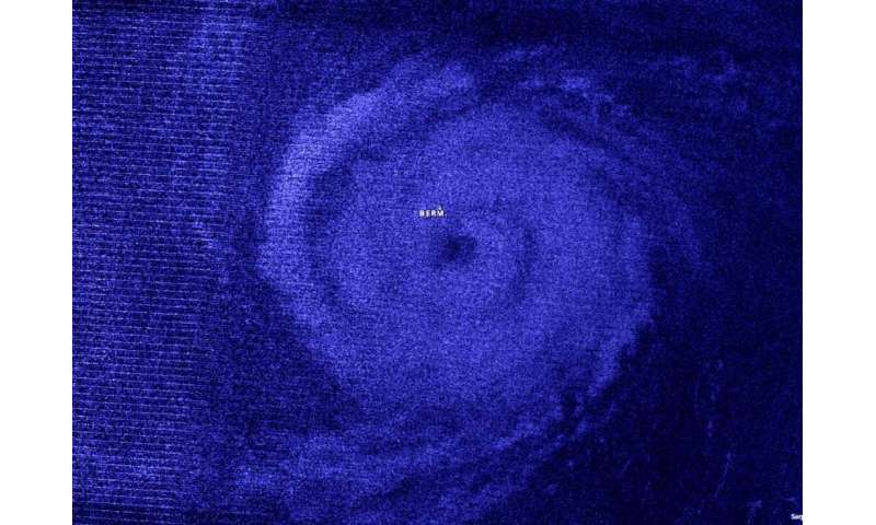
NASA night-time image shows Hurricane Paulette's large eye approach Bermuda
by Rob Gutro 
Night-time imagery from NASA-NOAA's Suomi NPP satellite showed Hurricane Paulette's large eye approaching the island of Bermuda. A Hurricane Warning is in effect for Bermuda.
Bermuda is a British territory in the western Atlantic Ocean. It is located approximately 643 miles (1,035 km) east-southeast of Cape Hatteras, North Carolina.
NASA's Night-Time View of Elida's Intensification
The Visible Infrared Imaging Radiometer Suite (VIIRS) instrument aboard Suomi NPP provided a nighttime image of Hurricane Paulette at 1:30 a.m. EDT (0530 UTC). The large eye, between 35 and 40 miles in diameter, was clearly apparent in the nighttime image, and it was surrounded by powerful thunderstorms. Hurricane-force winds extend outward up to 45 miles (75 km) from the center and tropical-storm-force winds extend outward up to 175 miles (280 km).
The image was created using the NASA Worldview application at NASA's Goddard Space Flight Center in Greenbelt, Md.
Hurricane Paulette's Status
At 5 a.m. EDT on Sept. 14, the eye of Paulette circled the entire island of Bermuda. The center of the eye of Hurricane Paulette was located over northeastern Bermuda or near latitude 32.3 degrees north and longitude 64.7 degrees west.
NOAA's National Hurricane Center (NHC) said Paulette is moving toward the north-northwest near 12 mph (19 km/h), and this motion should continue early this morning. A turn toward the north is expected by late morning and will continue into this afternoon. A faster motion toward the northeast is expected by this evening and will continue through Wednesday.
Maximum sustained winds have increased to near 90 mph (150 km/h) with higher gusts. Additional strengthening is likely when Paulette turns northeastward and moves away from Bermuda tonight through Tuesday. Although winds have subsided across much of Bermuda due to Paulette's eye passage, hurricane-force winds will return shortly when the southern portion of Paulette's eyewall passes over the island. Tropical-storm-force winds will continue possibly into the early afternoon across the entire island. The estimated minimum central pressure based on surface observations on Bermuda is 973 millibars.
Paulette's Forecast Track
At 5 a.m. EDT, the NHC noted that on the forecast track, the eye of Paulette will continue to pass over Bermuda during the next couple of hours, followed by passage of the southern portion of the eyewall.
About NASA's EOSDIS Worldview
NASA's Earth Observing System Data and Information System (EOSDIS) Worldview application provides the capability to interactively browse over 700 global, full-resolution satellite imagery layers and then download the underlying data. Many of the available imagery layers are updated within three hours of observation, essentially showing the entire Earth as it looks "right now."
NASA Researches Earth from Space
For more than five decades, NASA has used the vantage point of space to understand and explore our home planet, improve lives and safeguard our future. NASA brings together technology, science, and unique global Earth observations to provide societal benefits and strengthen our nation. Advancing knowledge of our home planet contributes directly to America's leadership in space and scientific exploration.
More information: For updated forecasts, visit: http://www.nhc.noaa.gov
Provided by NASA's Goddard Space Flight Center