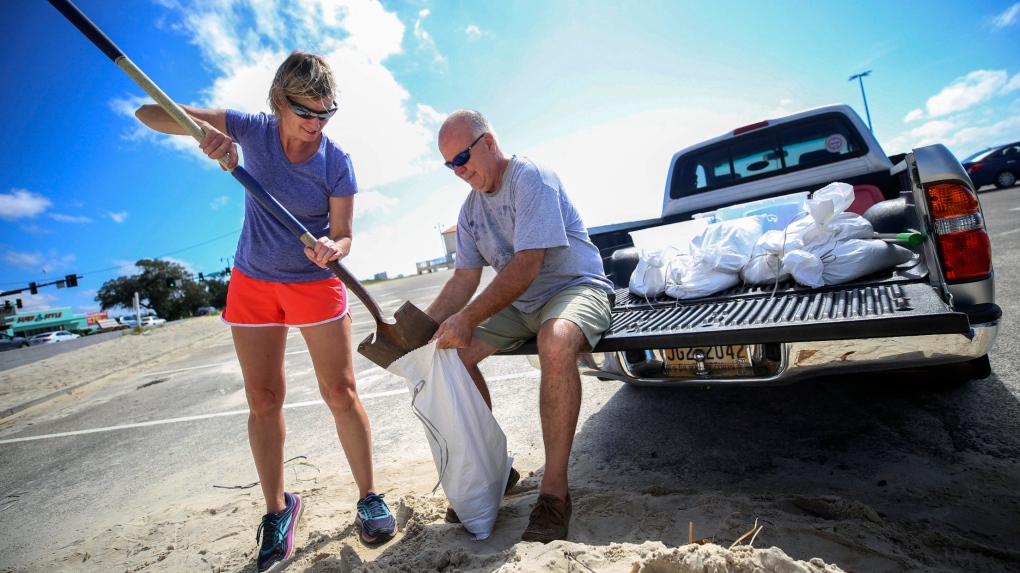
As Sally churns closer, U.S. Gulf Coast residents get ready
by Janet McConnaughey and Rebecca Santana The Associated Press Staff ContactNEW ORLEANS -- Storm-weary Gulf Coast residents rushed to finish last-minute preparations Monday as Tropical Storm Sally chugged slowly through warm Gulf waters. Forecasters predicted landfall as a hurricane, and said the biggest threat is flooding, with as much as two feet of rain falling in some areas.
"The bottom line continues to be that Sally is expected to be a dangerous slow-moving hurricane near the coast of southeastern Louisiana, Mississippi and Alabama during the next 2-3 days," the National Hurricane Center said early Monday.
Sally is perhaps the least welcome guest among lots of company: For only the second time in recorded history, there are five tropical cyclones churning in the Atlantic basin, meteorologist Philip Klotzbach said: Paulette, Rene, Teddy and now Vicky also are spinning over ocean waters.
Jeffrey Gagnard of Chalmette, Louisiana, spent Sunday in Mississippi helping his parents prepare their home for Sally -- and making sure they safely evacuated ahead of the storm.
"I mean, after Katrina, anything around here and anything on the water, you're going to take serious," he said, as he loaded the back of his SUV with cases of bottled water in a grocery store parking lot in Waveland, Mississippi. "You can't take anything lightly."
The National Hurricane Center said it was too early to tell exactly where Sally would come ashore, because it's still not known when it would make a turn to the north. At 10 a.m. local time, it was about 140 miles (230 kilometres) east-southeast of the mouth of the Mississippi River. Its top sustained winds were 65 mph (100 kmh) and it was moving toward the coast at just 6 mph (9 kph).
People in New Orleans were watching the storm's track intently. A more easterly landfall would likely bring the heavier rains and damaging winds onto the Mississippi coast, or east of that. Already outer bands from the storm were hitting the Florida Panhandle.
A more westerly track would pose another test for the low-lying city, where heavy rains have to be pumped out through a century-old drainage system. Officials with the Sewerage and Water Board said Sunday that all of the pumps were in operation ahead of the storm, but the aging system is also susceptible to breakdowns.
Sally is expected to become a hurricane Monday and reach shore by early Tuesday, bringing dangerous weather conditions, including risk of flooding, to a region stretching from the western Florida Panhandle to southeast Louisiana.
The Hurricane Center warned of an "extremely dangerous and life-threatening storm surge" for areas outside the levee protection system that protects the greater New Orleans area stretching from Port Fourchon, Louisiana, to the Alabama/Florida border.
"I know for a lot of people this storm seemed to come out of nowhere," said Louisiana Gov. John Bel Edwards Sunday. "We need everybody to pay attention to this storm. Let's take this one seriously."
In Mandeville, a city about 35 miles (56 kilometres) north of New Orleans, resident Chris Yandle has purchased a week's worth of groceries and moved all his patio furniture into his family's house and shed in preparation for the storm.
"I'm mostly trying to stay calm -- especially with a family of four and a dog to worry about," Yandle said. "I've lived through many hurricanes growing up in Louisiana, but I haven't felt this anxious about a hurricane in my life."
Mississippi officials warned that the storm was expected to coincide with high tide, leading to significant storm surge.
"It needs to be understood by all of our friends in the coastal region and in south Mississippi that if you live in low-lying areas, the time to get out is early tomorrow morning," Gov. Tate Reeves said late Sunday.
Pensacola, on Florida's Panhandle, was bracing for 10 to 15 inches (25 to 38 centimetres) of rain.
Sally could produce rain totals up to 24 inches (61 centimetres) by the middle of the week, forecasters said. Its maximum sustained winds Monday morning were near 65 mph (100 kph).
"That system is forecast to bring not only damaging winds but a dangerous storm surge," said Daniel Brown of the Hurricane Center. "Because it's slowing down it could produce a tremendous amount of rainfall over the coming days."
The entire island of Bermuda, where homes are built to withstand major hurricanes, was inside the eye of Hurricane Paulette on Monday morning. Once a tropical storm, Rene was forecast to become a remnant low Monday. Teddy became a tropical storm Monday morning, and was expected to become a hurricane later in the week, forecasters said. And Tropical Storm Vicky formed east of the Cape Verde islands.
A mandatory evacuation has already been issued in Grand Isle, Louisiana, ahead of Sally. On Saturday, New Orleans Mayor LaToya Cantrell issued a mandatory evacuation order for Orleans Parish residents living outside of the parish's levee protection system.
All northern Gulf Coast states are urging residents to prepare.
"It is likely that this storm system will be impacting Alabama's Gulf Coast. While it is currently not being predicted as a direct hit to our coastal areas, we know well that we should not take the threat lightly," said Alabama Gov. Kay Ivey. She urged residents to prepare and stay informed of the storm's path in the coming days.
------
Lush reported from St. Petersburg, Florida. Associated Press writers Julie Walker in New York; Haleluya Hadero in Lancaster, Pennsylvania; and Sudhin Thanawala in Roswell, Georgia; contributed to this report